
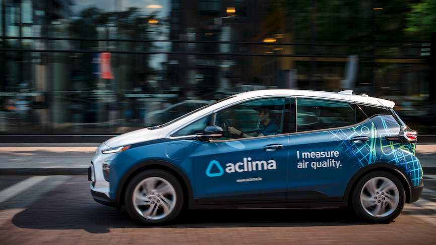
Map and analyze air pollution at the block-by-block level to inform public health policy and environmental regulations.
Utilize scientifically validated data from a managed network of mobile and stationary sensors to drive solutions.
What is Aclima?
Aclima: Map and analyze air pollution at the block-by-block level to inform public health policy and environmental regulations. No free plan. Zekai scores it 6.8 out of 10 after independent testing. Best for governments needing hyper-local pollution data for policy.
Zekai Verdict
- What is it?
- Aclima provides government agencies with an advanced air measurement and analysis platform.
- Best for
- Government agencies needing hyper-local, scientifically validated air quality data to drive environmental policy and…
- Not ideal for
- Pricing is not transparent and likely represents a significant public investment.
- Price
- Pricing on request
- Zekai Score
- 6.8/10
 Technosylva
 SewerAI
 FiscalNote
 Carbyne
 Ecopia AI
 FIDO Tech
 Optibus
For government and smart city applications, Aclima is the best AI-powered tool for mapping air pollution at a hyper-local level. It uses a proprietary network of mobile and stationary sensors to provide block-by-block data on pollutants and greenhouse gases, which is up to 100,000x more detailed than traditional methods. This enables precise, data-driven environmental policy, urban planning, and public health initiatives.
Before & After
Relying on sparse, regional air quality data that misses neighborhood-level hotspots.
City-wide air quality indexAccessing block-by-block pollution data to make targeted, evidence-based policy decisions.
Block-level pollution mapsTry it with these prompts
Copy any prompt and paste it directly into the tool.
Generate a high-resolution map of air pollution in a specific urban area. Input the geographic boundaries and the primary pollutants of concern to identify pollution hotspots at the block-by-block level for public…
Analyze the chemical fingerprint of air quality in a neighborhood by tracking multiple pollutants, including greenhouse gases and toxics, at the same time.
Obtain scientifically validated air pollution data for a region using Aclima's advanced measurement platform. Request data for a specified period and pollutants to support research or policy-making.
Prompts for Government
Trusted by professionals
Aclima integrations
Best Aclima alternatives
Compared to traditional government-run stationary air quality monitors, Aclima offers vastly superior spatial resolution and flexibility. Stationary monitors provide reliable, long-term trend data for a wide region but miss street-level variations. Aclima's mobile sensor fleet maps pollution block-by-block, identifying hotspots that fixed sensors cannot see. Choose traditional monitors for regional compliance and baseline reporting. Choose Aclima when you need granular, actionable data to inform targeted public health interventions, environmental justice programs, or smart city traffic management.
Is Aclima worth it?
Why Government & Smart Cities choose this tool
Key Use Cases
Aclima is a game-changer for data-driven environmental governance, offering unparalleled granularity in air quality mapping. Its managed service model makes sophisticated science accessible. The main trade-off is its dependency on Aclima's physical network deployment in your region and a likely significant cost, as pricing is not public.
Frequently asked questions
What is the best AI tool for a city government to map air pollution?
How does Aclima's data resolution compare to traditional air quality monitoring?
Can Aclima's platform be used for environmental justice initiatives?
What types of pollutants can Aclima measure?
How can I get hyper-local air quality data for my jurisdiction?
Is the data from Aclima scientifically reliable for policy-making?
Last reviewed:
Aclima pricing and plans
Prices and features are updated regularly but can change at any time — always confirm on the official website. Some links on this page are affiliate links.
Top 10 AI tools in this category


Take it with you
- The limitations of traditional, city-wide air quality monitoring.
- How mobile sensing provides a 100,000x more detailed view of pollution.
- Identifying pollution hotspots and their impact on public health.
- Using granular data for environmental justice initiatives.
- Case Study: How California's CARB uses hyper-local data.
Get Aclima deal alerts
Be the first to know when Aclima drops a new discount, adds features, or changes pricing.
More on AI for Government & Smart Cities
Latest AI news



About Aclima
Full Description
Aclima provides government agencies with an advanced air measurement and analysis platform. It uses a network of roving and stationary sensors to deliver hyper-local data on air pollution, greenhouse gases, and toxics, enabling data-driven policy and public health initiatives.
Editorial Verdict
Aclima is a game-changer for data-driven environmental governance, offering unparalleled granularity in air quality mapping. Its managed service model makes sophisticated science accessible. The main trade-off is its dependency on Aclima's physical network deployment in your region and a likely significant cost, as pricing is not public.


