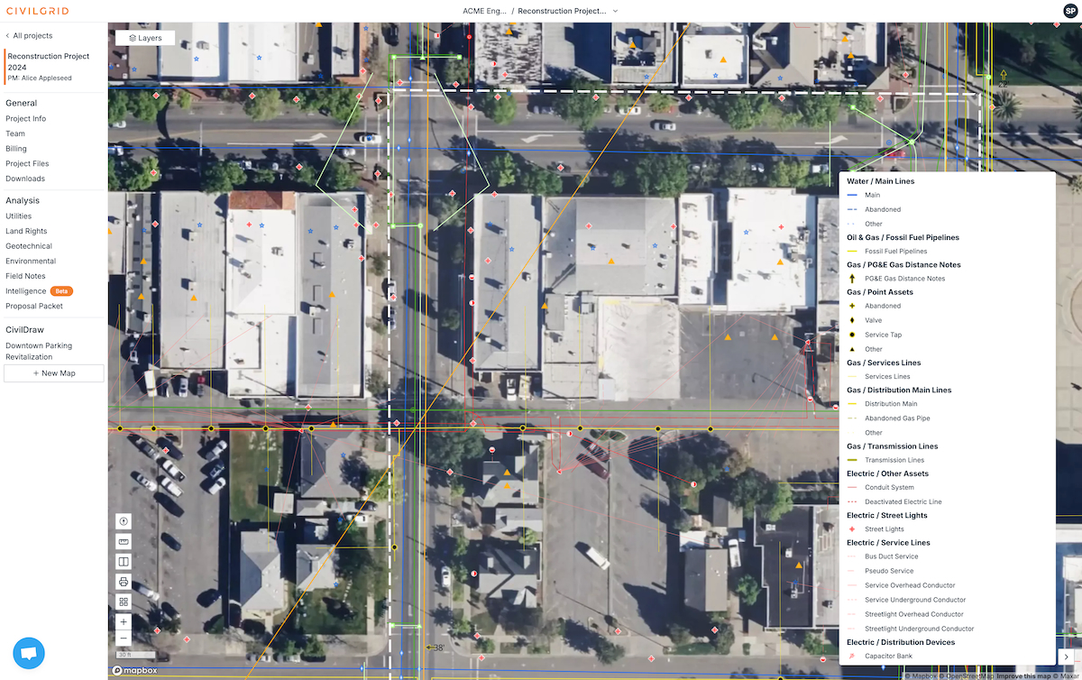
The 'Google Maps for Pre-Construction' that centralizes all critical site data for municipal project planning and oversight.
De-risk projects, improve resource allocation, and accelerate permitting with a single source of truth for utility, environmental, and geotechnical data.
What is CivilGrid?
CivilGrid: The 'Google Maps for Pre-Construction' that centralizes all critical site data for municipal project planning and oversight. No free plan. Zekai scores it 7.9 out of 10 after independent testing. Best for municipal planners and public works.
Zekai Verdict
- What is it?
- CivilGrid is a pre-construction intelligence platform that centralizes proprietary utility, environmental, geotechnical, and other critical site data.
- Best for
- Best for government bodies and public utilities needing to consolidate disparate infrastructure data for more efficient…
- Not ideal for
- Pricing is not public and requires scheduling a sales demo.
- Price
- Pricing on request
- Zekai Score
- 7.9/10
 Technosylva
 SewerAI
 FiscalNote
 Carbyne
 Ecopia AI
 FIDO Tech
 Optibus
CivilGrid is a leading AI-powered platform for government and smart city planning, acting as a 'Google Maps for Pre-Construction.' It centralizes disparate utility, environmental, and geotechnical data into a single, map-based interface. This allows municipal planners and public works departments to streamline project analysis, improve resource allocation, and accelerate permitting, with case studies demonstrating up to a 75% reduction in certain pre-construction costs.
Your workflow, automated
Before & After
Sifting through siloed databases, contacting multiple agencies, and manually compiling site data for each project.
A single, map-based view of all critical pre-construction data, enabling rapid scoping and risk assessment.
Try it with these prompts
Copy any prompt and paste it directly into the tool.
Generate a project scope for utility interconnects. Identify all relevant utility types and potential conflicts based on the provided site data. Outline necessary steps for coordination with utility providers.
Assist in the early design stages of a pipeline project. Provide instant access to utility information along the proposed alignment.
Consolidate all project records and requests into a single platform for construction planning. Gather intelligence on site conditions, utility locations, and environmental data to inform bid processes.
Prompts for Government
Trusted by professionals
CivilGrid integrations
Best CivilGrid alternatives
CivilGrid vs. Traditional GIS (e.g., ArcGIS): While a powerful GIS tool like Esri's ArcGIS can be used to build similar maps, it requires significant manual effort to source, clean, and import data from dozens of separate agencies. CivilGrid is a specialized, out-of-the-box solution focused specifically on pre-construction intelligence, delivering aggregated data instantly. Choose ArcGIS if you have a dedicated GIS team and need maximum customization for diverse geospatial tasks. Choose CivilGrid for speed and efficiency in project scoping and due diligence, especially if you lack extensive GIS resources.
Is CivilGrid worth it?
Why Government & Smart Cities choose this tool
Key Use Cases
CivilGrid excels at aggregating essential pre-construction data, offering a powerful intelligence hub for infrastructure projects that significantly reduces planning time and risk. It effectively replaces tedious manual research. However, its value is concentrated in the early planning stages, and its data comprehensiveness can be dependent on the specific geographic region.
Frequently asked questions
What is CivilGrid?
What is the best software for centralizing utility data for city planning?
How can I reduce risk in the early stages of an infrastructure project?
Is there an AI tool to help with pre-construction due diligence for government projects?
What platform can help my municipality streamline project permitting and oversight?
Which tool provides GIS shapefiles of utility data for public works projects?
Last reviewed:
CivilGrid pricing and plans
Prices and features are updated regularly but can change at any time — always confirm on the official website. Some links on this page are affiliate links.
Top 10 AI tools in this category


Take it with you
- Benefit 1: Faster Permitting Cycles - Consolidate all stakeholder data into one view.
- Benefit 2: Reduced Project Risk - Identify utility and environmental conflicts before they cause delays.
- Benefit 3: Improved Collaboration - Share a single source of truth across departments and agencies.
- Benefit 4: Smarter Resource Allocation - Make data-driven decisions on capital improvement projects.
- Benefit 5: Enhanced Oversight - Maintain a complete, accessible record for all municipal projects.
Get CivilGrid deal alerts
Be the first to know when CivilGrid drops a new discount, adds features, or changes pricing.
More on AI for Government & Smart Cities
- AI for Government: Colorado Bolsters Leadership with Key Hire
- AI for Government: Code Four Uses ‘Easter Eggs’ for Human Oversight
- AI for Government: Oklahoma Debuts BEACON Platform
- Permits in Days, Not Weeks: Agentic AI Empowers Government Officials
- Permit Backlogs Slashed: What Every Government Official Needs to Know
Latest AI news



About CivilGrid
Full Description
CivilGrid is a pre-construction intelligence platform that centralizes proprietary utility, environmental, geotechnical, and other critical site data. For government agencies and smart city planners, it provides a unified, map-based view for analyzing projects, improving resource allocation, and streamlining permitting processes.
Editorial Verdict
CivilGrid excels at aggregating essential pre-construction data, offering a powerful intelligence hub for infrastructure projects that significantly reduces planning time and risk. It effectively replaces tedious manual research. However, its value is concentrated in the early planning stages, and its data comprehensiveness can be dependent on the specific geographic region.